Planning Terminology Chart
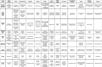
The chart (download here) compares Canadian land use planning terminology across the provinces and territories, but its compact form does not reflect the rich diversity of current practice. It concentrates on land use planning legislation. There is no substitute for reviewing the appropriate legislation, now available on the internet for all jurisdictions (links to access online legislation can be found here)
Provincial Planning Legislation
The first column in the chart describes the key act where most of the land use planning authority resides. Sometimes planning authority is embedded in a larger act covering municipal governments.
Plan/Zoning Appeal Body
Most jurisdictions employ some form of administrative tribunal to review municipal planning decisions. The tribunal format varies widely from complex de novo hearings at the provincially-appointed Ontario Municipal Board to locally-appointed appeal boards in Nunavut and the NW Territories. The sorts of decisions that can be appealed and the appeal process vary widely across jurisdictions.
Regional Plan
All jurisdictions enable preparation of plans that deal with large areas, and more than one municipality. Once again, the practice varies widely across the nation. The plans are often advisory, and not every jurisdiction is covered by a regional plan.
Municipal Land Use Plan
Almost every Canadian municipality has a comprehensive land use plan, but the documents have different names in each jurisdiction. The form and content of the plans are loosely defined in the enabling legislation, but more detailed guidance may be found in supporting provincial/territorial policies.
District Plans
Many municipalities are too large for their comprehensive plan to provide detailed land use guidance, so they use some form of district plans for neighbourhoods, industrial or commercial areas, or redevelopment areas. The content, status and approval process for these secondary plans varies across municipalities – some plans are simple generic land use diagrams, while others are based on detailed master plans.
Street & Block Layout
Some jurisdictions encourage a plan that shows a layout of the streets and blocks, operating between the levels of detail of the general policies of a district plan and a detailed plan of subdivision for every parcel. These plans are usually for guidance and often do not have legislative authority.
Land Subdivision
All jurisdictions require control and approval of plans to subdivide land. Subdivision plans are often approved in two phases: a preliminary plan for review and a final plan that legally subdivides the property.
Zoning Bylaws
Most municipalities regulate the uses of property and general form of buildings through zoning bylaws.
Site Plan Review
All jurisdictions allow municipalities to review and approve the detailed design of building site plans, using some form of development permit system. Building location, drainage, landscaping, access parking and servicing are typical concerns for this type of plan. The content and process of site plan review may vary widely across municipalities, although provincial/territorial legislation may limit the scope of the process, especially regarding the design of individual buildings.
The chart is as accurate as we could get in 2020. We expect to update at every few years as legislation changes. Please send comments to PlanningCanadianCommunities@gmail.com. The chart is adopted from the article “Lost in Transition: A brief comparison of Canadian land use planning terminology” by David LA Gordon and Tasha Elliott, published in Plan Canada, Volume 47:2, Spring 2007, pp. 28-31.